Parthenon Sandstone overlying Brentwood Limestone on Felkins Creek, Weathers quadrangle
Recently, geologists at the Arkansas Geological Survey (AGS) completed geologic mapping of the Weathers and Delaney quadrangles in northwest Arkansas. These quadrangles are part of the U. S. Geological Survey’s 7.5-minute topographic series and cover an area of approximately 120 square miles. This project was made possible by a grant from the National Cooperative Geologic Mapping Program of which STATEMAP is a part. This year marks the 25th year of STATEMAP projects in Arkansas and represents an unprecedented commitment to gathering data on the geologic features of our State. STATEMAP was established in 1992 by an act of Congress to encourage the states to map their geology at the 1:24,000 scale. The first grant received by the Arkansas Geological Survey, then known as the Arkansas Geological Commission, was for a proposal in fiscal year 1994. Since that time, eighty, 1:24,000-scale geologic maps have been completed, including the Weathers and Delaney quads.
Printed copies of the new geologic maps (and many others) are available at the AGS office in Little Rock for $12.50, but they are also available as a free download in .pdf form on our website. Here’s the link to the Delaney Quadrangle:
https://www.geology.arkansas.gov/docs/pdf/maps-and-data/geologic_maps/24k/Delaney.pdf

And here’s the link to the Weathers Quadrangle:
https://www.geology.arkansas.gov/docs/pdf/maps-and-data/geologic_maps/24k/Weathers.pdf

STATEMAP, which is administered by the U. S. Geological Survey, provides Arkansas with federal dollars through an annual grant proposal process. These funds are matched by the AGS which then performs all the work necessary to produce new geologic maps for the State. This year’s grant enabled the AGS to hire a geologist and to partially cover expenses incurred during field work. Garry Hatzell and staff geologist Richard Hutto worked together as a team during the data collection and map production phases of the project. This team approach has worked well for the AGS during its long history of geologic mapping, both for safety and efficiency.
The goal of STATEMAP is to classify bedrock exposed at the surface into recognizable units, such as formations and members, based on a common lithology—basically, an areal inventory of surface materials. Unfortunately, bedrock outcrops are few and far between in our State because so much of the surface is covered by alluvium (stream deposits) or colluvium (slope deposits). Since we are mapping the bedrock geology, we have to find ways to see through this cover and infer what is beneath it. We do map certain types of surficial deposits in some areas, however. Along the valleys of mature streams for instance, alluvium and terrace deposits are mapped. On steep hillsides, various types of debris flows considered to have moved in the recent past are mapped as landslides. Structural features, such as faults or folds, that offset or deform rock units are also described and mapped. In areas where the bedrock is covered, these relationships are inferred from data gathered nearby where outcrops are better.


Recent landslide in the Atoka Formation on the Delaney quad (left) and boulders of Parthenon sandstone in Kings River on the Weathers quad (right)
For this reason, much of our data collection efforts are concentrated on stream beds. There, erosional processes have typically removed soil and loose rock leaving sporadic, well-exposed outcrops of bedrock to study. Also, following a streambed allows us to see strata from bottom to top (or vice versa) which puts each formation in context with others. Locating and describing the physical contacts between formations is one of the most important things we do while mapping. Because formations are laterally extensive, disparate points taken on similar contacts can be connected across the mapping area to delineate each formation. Drawing these contact lines between formations in the correct location is a major focus of the mapping process.


Contact between the Parthenon and Brentwood Members of the Bloyd Formation on the Weathers quad at Kings River Falls (left) and on the Delaney quad in Crosses Creek (right)
Currently, the AGS’s STATEMAP projects are focused on the Ozark Plateaus Province, part of the Interior Highlands Physiographic Region located in the northern part of the State. The Ozark Plateaus in Arkansas consist of three broad surfaces that have developed due to differential erosion of Paleozoic sedimentary rocks on the southern flank of the Ozark Dome. Weathers and Delaney lie within the Boston Mountains Plateau, the southernmost and highest of these three surfaces. On these quads, over 1000 feet (305 meters) of Mississippian to Pennsylvanian (Chesterian, Morrowan, and Atokan) carbonate and clastic rocks are exposed. These rocks formed from sediment deposited in distal to near shore marine, tidal, deltaic, and fluvial environments.

On the Boston Mountains Plateau, looking west toward Delaney from Boston.
In this area, the White River is increasingly being utilized as a public water source. Because of its importance in this regard, there is a lot of interest in gathering baseline data in this watershed. Most of the Delaney quad is drained by the White River, the uppermost reaches of the Middle Fork of the White River, and numerous smaller tributaries of the White. Some small drainages along the west side of the quad and Frog Bayou along the southern edge drain to the Arkansas River. Most of Weathers quad is drained by the Kings River and its tributaries as well as upper reaches of War Eagle Creek and the Buffalo River, all of which contribute to the White. Field work this year included hiking, wading, and swimming about 4.5 miles of the White River and 7 miles of the Middle Fork of the White River on the Delaney quad. 11 miles of the Kings River and 10.5 miles of Felkins Creek were traversed on the Weathers, along with numerous other streambeds on both quads.


Close examination of fossiliferous Brentwood Limestone in White River on Delaney quad (left). Crinoid detritus including spines and cup plates in the Brentwood in Cowcumber Creek on Weathers quad (right)
The most significant structural feature on Weathers is the Russell Ridge Monocline, the axis of which is oriented parallel to other northeast-trending faults and lineations in northwest Arkansas. Presumably these align with regional faulting of Precambrian basement rock. The strata are depressed approximately 200 feet (61 meters) from southeast to northwest across this structure. Various normal faults with throws from 60-100 feet (18-20 meters) were also mapped. In the northwest corner of Delaney, the Drakes Creek Fault, a normal fault that also trends northeast, is downthrown to the southeast approximately 200 feet (61 meters).

Yellow line marking the trace of a normal fault in Whispering Hollow on Weathers. Pitkin (Mp) downthrown to Fayetteville (Mf) approximately 60 feet (18 meters)
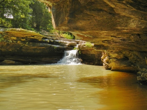
The Ozark National Forest occupies parts of the southern two thirds of Delaney and the southern third of Weathers. It is managed by the U. S. Forest Service. Along a reach of the Kings River in the southern part of Weathers is the Kings River Falls Natural Area which is maintained by the Arkansas Natural Heritage Commission.

Kings River Falls, the centerpiece of the 1059-acre Kings River Falls Natural Area
Field work commenced on July 16, 2018 and was finished on March 28, 2019 for a total of 75 days. From early April through the end of June, the geologists analyzed field data, classified rock specimens, and wrote descriptions specific to each quadrangle. Contacts and structural features were drawn on a topographic map base both digitally and by hand. Brian Kehner and Kerstein Dunn helped digitize and symbolize the map elements in ArcMap, developed alternative base maps, and integrated field data into our seamless geodatabase. Final layout of the maps was accomplished in Adobe Illustrator by Garry Hatzell, and they were edited by AGS geologic staff.


Massive calcareous sandstone in the Prairie Grove Member of the Hale Formation in Kings River on Weathers (left). Thin-bedded sandstone in the Atoka Formation in Shrader Branch on Delaney (right)
Special thanks to Ciara Mills for accompanying us in the field several weeks this year. Also to Angela Chandler for writing the proposal and serving as Principal Investigator again this year. Her guidance and support of geologic mapping in the State inspires us all to do great things. Very special thanks to Jerry and Joan Johnson of Madison County whose hospitality and knowledge of the people and places in the mapping area provided invaluable support for our endeavor this year.


Joan Johnson, Richard Hutto, and Jerry Johnson by Little Mulberry Creek (left) and Angela Chandler on North Sylamore Creek (right)
Next year, STATEMAP is heading farther north to the Salem Plateau where Scott Ausbrooks, Bill Prior, and Garry Hatzell will be mapping the Mammoth Springs quadrangle. So if you see someone up there taking an unusually keen interest in the rocks, be sure to say hello.
Until next time, I’ll see you in the field!
Richard Hutto

Garry Hatzell and Richard Hutto—out standing in the field