Tag Archives: Geology

Happy Geologic Map Day – Earth Science Week 2023

Why are geologic maps important?

The answer cannot be stated any better than the following:

 “The first geology map was prepared to solve practical problems involving the distribution of different types of rocks at and near the Earth’s surface, and that is still the reason geologic maps are made today.  Uses of geology maps first expanded into exploration for natural resources, including minerals and petroleum.  As an example, during World War II, maintaining the supply of strategic minerals became so critical that geologists in the U.S. military were assigned to make geologic maps for mineral exploration.”

“Most building materials, except wood, are from various specific rocks and rock products. The suitability of rocks and unconsolidated surficial materials to support foundations is essential for construction of homes, skyscrapers, dams, bridges, or simply a road. Rocks and unconsolidated surficial materials fundamentally affect the nature of the soil cover and plant growth is related to soil type.”  (Thomas, 2004)

And don’t forget, we are all familiar with spectacular natural disasters, such as earthquakes, volcanoes, storms, and floods! What’s in a geologic map?
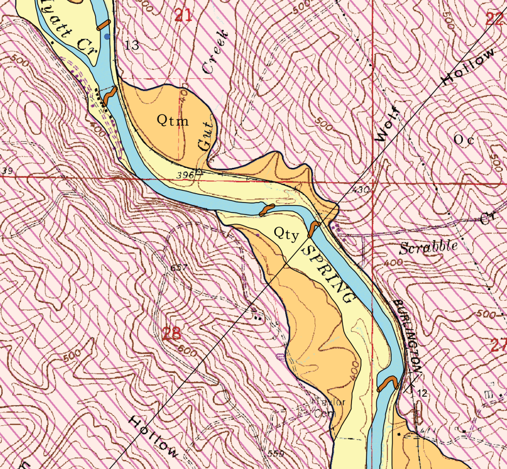
This map is a detail from a larger map, the Geologic Map of the Stuart Quadrangle in northeast Arkansas. This geologic map shows which rock formations and alluvial deposits are exposed at the surface as well as water sample sites, travertine dams, and the orientation of inclined bedding.

The orange and yellow colors (Qty and Qtm) represent alluvium in the form of terraces that were deposited by the Spring River. The brown squiggly lines (Qcd) crossing the Spring River represent travertine dams (Qcd). Travertine dams are made up of the same material as cave deposits, calcium carbonate. They are an important feature to highlight on the map because they can erode and become undercut causing them to become a hazard. The pink patterned color represents the Cotter Formation (Oc). The blue dot near the top of the map labeled “13” represents a water sample site. The symbol at the end of the word “BURLINGTON” is a strike and dip symbol. This symbol indicates that beds of the Cotter Formation at this location are dipping 12 degrees to the southeast.

If you are interested in geologic maps published by the OSG and want to learn more about our mapping program, then visit the link provided below:

https://www.geology.arkansas.gov/geology/arkansas-geological-mapping-program.html

For a full listing of our geologic maps, please visit:

https://www.geology.arkansas.gov/maps-and-data/geologic-maps.html

Reference:  

Thomas, W. 2004, Meeting challenges with geologic maps:  American Geological Institute Awareness Series.

Trilobites from the Powell Dolomite and Imo interval of northern Arkansas

Trilobite Fossil in Powell Dolomite-north Arkansas

Happy National Fossil Day! To celebrate, we’d like to tell you a little about one of the many varieties of fossils preserved in the rocks of Arkansas. One of the most recognizable and perhaps popular invertebrate fossils anywhere is the trilobite. The photograph above shows the external mold of the middle (thorax) and tail (pygidium) portions of a trilobite that lived in the Ordovician period. It was preserved in the Powell Dolomite in north Arkansas and only recently made its way back to the surface after millions of years of erosion removed all the rock that had covered it. It measures about 3 inches in length. This specimen is the largest trilobite ever found in the rocks of Arkansas. Preserved portions of smaller trilobites and trilobite parts are commonly found in several formations located in various parts of the state depending on whether conditions were favorable for them to have lived there and to be buried after death.

Trilobites belong to a class of extinct Arthropods that lived in ancient, warm, shallow seas for millions of years from the Cambrian to the Permian Periods (the Paleozoic Era), however, they were most abundant in the Cambrian and Ordovician Periods (541 to 444 million years ago). The class went extinct near the end of the Permian Period, meaning their very existence is based entirely on the fossil record they left behind. They were small, averaging about 5 to 8 centimeters (2 to 3 inches) in length, but giant specimens could reach lengths of nearly 75 centimeters (30 inches). They lived their life crawling about on the floor of ancient seas, occasionally making a mark or depression in the sediment. Where these are preserved, they are known as trace fossils and can be used to help interpret trilobite behavior. To see a photo of a trilobite trace fossil, check out this link to another blog post on our page:

https://arkansasgeological.wordpress.com/2019/02/14/geo-pic-of-the-week-trilobite-romance/

Occasionally, a few specimens became buried in the sediment, and the hard parts of some became preserved over time as the sediment became rock. Much more commonly preserved, however, were various fragments of trilobite exoskeleton. In order to grow, trilobites actually needed to cast off pieces of their carapace during a molting process. This process, which could happen 2 to 3 times per year, resulted in a buildup of disarticulated fragments on the sea floor. Because of their sheer numbers, these parts are much more likely to be preserved than whole specimens. Many species of trilobite are known only by the study of these partial remains by dedicated paleontologists.

During deposition of the Powell Dolomite, the area recently known as Arkansas was much closer to the equator and was covered by a shallow sea. These warm waters provided a perfect environment for these critters and others to survive and thrive here. Preservation, though rare, gives us insight into the diversity of marine organisms, including trilobites, that lived here during that time.

The trilobites pictured below lived at a much later time but are found in a similar environment. At the very end of the Mississippian, an influx of clay, silt, and sand shed from the newly formed Appalachian Mountains to the east began to be deposited in the shallow sea that still covered northern Arkansas. Many species of trilobite lived, grew, and molted in the shallow estuaries common in the area at that time. The Late-Mississippian Imo interval has preserved many trilobite parts along with numerous other marine species in shaly sections deposited in those estuaries. Following are photos of some of the Imo-aged trilobite parts:

Trilobite parts in Imo interval-north Arkansas

Middle and tail portion of a trilobite from the Mississippian Imo interval. Penny for scale.

Rolled-up Trilobite parts in Imo interval-north Arkansas

Eyes in the head portion of a rolled-up trilobite from the Mississippian Imo interval. Penny for scale.

To find out more about Arkansas Trilobites, check out Plate IX on page 54 in the Arkansas Geological Survey’s Bulletin 22-Fossils of Arkansas. This is a great little book that also discusses other common fossil species found in our state:

https://www.geology.arkansas.gov/docs/pdf/publication/bulletins/bulletin%20-22-fossils-of-ar.pdf