Happy Geoscience for Everyone Day – Earth Science Week 2023

It’s Geoscience for Everyone Day! Today, we focus on encouraging everyone, including minorities, people of all gender orientations, and those with a range of abilities to study geosciences!

Over the past few years, multiple publications and scientific websites have examined the issue of physical accessibility in the geoscience profession. Multiple disciplines under the geoscience umbrella require people to conduct field work in rough terrain, which is not always easy for those with limited mobility. Additionally, many undergraduate courses in geology have a field trip component that requires students to travel to remote exposures and hike over rough terrain.

Although much work still needs to be done, paved trails and technology have allowed students and geoscientists with limited physical mobility to participate in data collection and field observation. For those interested in designing accessible field experiences in Arkansas, the Office of the State Geologist has three State Park Series publications available: Crater of Diamonds State Park, Hobbs State Park, and Petit Jean State Park. All three parks offer accessible facilities and/or trails. This includes the Little Missouri River trail in Crater of Diamonds, the Cedar Falls Overlook trail in Petit Jean, and the Ozark Plateau and Historic Van Winkle Trails in Hobbs State Park-Conservation Area. The Hobbs State Park publication even has geologic trail maps available. These publications can be accessed on our website: https://www.geology.arkansas.gov/publication/state-park-series.html

For additional information, please see the following resources regarding physical accessibility in geoscience:

https://theiagd.org/ – The International Association for Geoscience Diversity

https://sites.google.com/ufl.edu/geospace-field-program – An accessible field course for students at the University of Florida

https://rock.geosociety.org/net/gsatoday/science/G462A/GSATG462A.pdf – Using Mobile Technologies to Enhance Accessibility and Inclusion in Field-Based Learning

https://pubs.geoscienceworld.org/gsa/geosphere/article/15/6/1809/574966/Making-geoscience-fieldwork-inclusive-and – Making geoscience fieldwork inclusive and accessible for students with disabilities

Happy Geologic Map Day – Earth Science Week 2023

Why are geologic maps important?

The answer cannot be stated any better than the following:

 “The first geology map was prepared to solve practical problems involving the distribution of different types of rocks at and near the Earth’s surface, and that is still the reason geologic maps are made today.  Uses of geology maps first expanded into exploration for natural resources, including minerals and petroleum.  As an example, during World War II, maintaining the supply of strategic minerals became so critical that geologists in the U.S. military were assigned to make geologic maps for mineral exploration.”

“Most building materials, except wood, are from various specific rocks and rock products. The suitability of rocks and unconsolidated surficial materials to support foundations is essential for construction of homes, skyscrapers, dams, bridges, or simply a road. Rocks and unconsolidated surficial materials fundamentally affect the nature of the soil cover and plant growth is related to soil type.”  (Thomas, 2004)

And don’t forget, we are all familiar with spectacular natural disasters, such as earthquakes, volcanoes, storms, and floods! What’s in a geologic map?

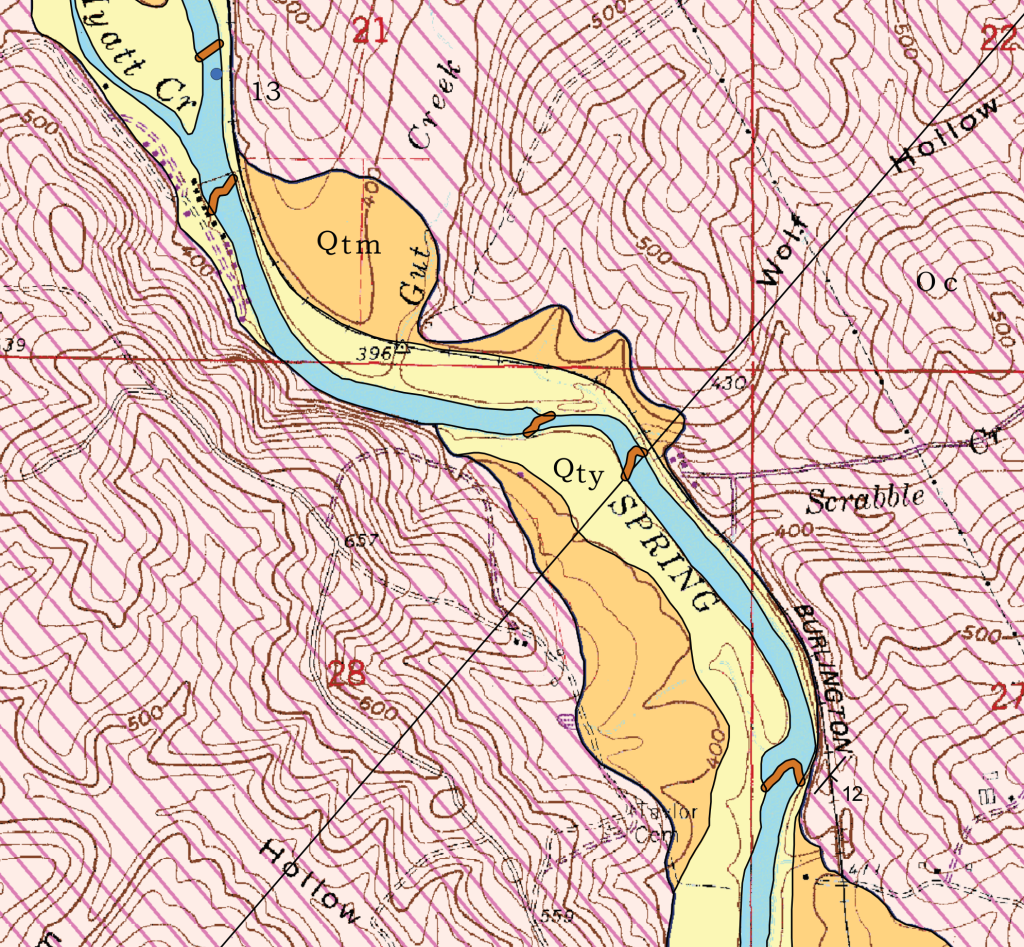
This map is a detail from a larger map, the Geologic Map of the Stuart Quadrangle in northeast Arkansas. This geologic map shows which rock formations and alluvial deposits are exposed at the surface as well as water sample sites, travertine dams, and the orientation of inclined bedding.

The orange and yellow colors (Qty and Qtm) represent alluvium in the form of terraces that were deposited by the Spring River. The brown squiggly lines (Qcd) crossing the Spring River represent travertine dams (Qcd). Travertine dams are made up of the same material as cave deposits, calcium carbonate. They are an important feature to highlight on the map because they can erode and become undercut causing them to become a hazard. The pink patterned color represents the Cotter Formation (Oc). The blue dot near the top of the map labeled “13” represents a water sample site. The symbol at the end of the word “BURLINGTON” is a strike and dip symbol. This symbol indicates that beds of the Cotter Formation at this location are dipping 12 degrees to the southeast.

If you are interested in geologic maps published by the OSG and want to learn more about our mapping program, then visit the link provided below:

https://www.geology.arkansas.gov/geology/arkansas-geological-mapping-program.html

For a full listing of our geologic maps, please visit:

https://www.geology.arkansas.gov/maps-and-data/geologic-maps.html

Reference:  

Thomas, W. 2004, Meeting challenges with geologic maps:  American Geological Institute Awareness Series.