Monthly Archives: May 2017

Geo-pic of the week: Slickensides

Slickensidedshale_edited

The grooved surface pictured above is a slickenside.  Slickensides indicate the relative direction of movement between fault blocks (hanging wall moved up, down, laterally, etc..).  

Slickensides form when fault blocks move against each other.  The natural irregularities on each scratches grooves into the other.  The grooves are parallel to movement;  for instance in this example, movement was either to the right or the left.  To tell whether it was right or left, you can rub your hand along the slickensides.  They feel smooth in the direction the fault moved and rough in the opposite direction – it’s like petting a dog from tail to head.  Slickensides are a valuable tool because determining fault movement can be a challenge when there are no easily-recognized beds that can be correlated across the fault to show the sense of offset.

The shale above was photographed in Big Rock Quarry, North Little Rock, AR.  It’s a part of the Jackfork Formation (Pennsylvanian).

Geo-pic of the week: Syn-depositional Faulting

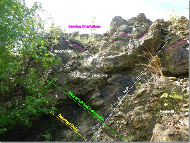
Fault with lables


Pictured above is one of many faults, closely spaced together, in an outcrop of the Atoka Formation, near Lake Fort Smith, Arkansas.  The fault pictured extends from the upper right to the lower left and is highlighted.  This type of faulting is called syn-depositional faulting, meaning it occurred at about the same time the rock was being deposited.  It results in disturbed-looking outcrops like this one.

Around 300 million years ago, plate tectonic forces were deforming the Ouachita Mountains in south central Arkansas. Those forces also caused faulting in the southern Ozark Plateaus, as the sediment that composes this rock outcrop was being deposited.  The freshly deposited sediment wasn’t fully consolidated when the faulting took place and the rock surrounding the fault got contorted by the stress. 

Some of the deformed features of the outcrop are labeled above.  The Zone of Soft-Sediment Deformation is the area surrounding the fault where the rock has been deformed by shearing: there is no recognizable bedding in that zone.  The soft clay-rich Deformed Shale was squeezed plastically between the fault blocks in that soft sediment deformation zone.  The bedding orientations surrounding the deformation zone (indicated by magenta lines) vary greatly, because the soft bedrock was broken and heaved around by the fault.