Tag Archives: Durham

Cannon Creek Waterfall at Parthenon/Brentwood Contact

Notes from the Field-Durham Quadrangle


Geologic Map of the Durham Quadrangle, Madison and Washington Counties, Arkansas

Geologic mapping of the Durham 7.5-minute quadrangle in northwest Arkansas was recently completed by the STATEMAP field team.  STATEMAP in Arkansas is currently focused on detailed 1:24,000-scale mapping in the Ozark Plateaus Region in north Arkansas.  It is accomplished through a cooperative matching-funds grant program administered by the US Geological Survey.   Field work was performed between July and February, and included hiking/wading/swimming the entire 12-mile stretch of the upper White River located on the quad.  Previous mapping delineated five stratigraphic units for the 1:500,000-scale Geologic Map of Arkansas, but at the 1:24,000 scale, we were able to draw ten. Further division is possible, but several units were considered too thin to map on the available 40-foot contour interval.

You can download your own copy of the map at this link:

Click to access Durham.pdf


DurhamStratColumn

Generalized Stratigraphic Column of Durham Quadrangle

The Drakes Creek Fault, which runs diagonally from the southwest corner to the northeast corner, is the most striking feature on the map.  It is part of a major structural feature in northwest Arkansas, forming a lineament that can be traced at the surface for over 45 miles.  The Drakes Creek displays normal movement, is downthrown to the southeast, and offsets strata an average of 230 feet.  Associated with the fault on the northwest side is a large drag fold. There, rocks parallel to the fault are deformed such that units typically present at higher elevations away from the fault bend down to a much lower elevation next to the fault.  Erosion along this side of the fault has exposed the core of the fold along Fritts Creek, Cannon Creek, and other places.

image

Detail of Cross-section of Durham Quadrangle

The Durham quad is far-removed from areas of previous STATEMAP projects in north Arkansas.  We completed work on the Mountain View 1:100,000-scale quad last year, ending on the Brownsville quad near Heber Springs.  Focus has now turned to the Fly Gap Mountain 1:100K quad as the next high-priority area.  When completed, we will have continuous 1:24K coverage for a large portion of the central Ozark Plateaus Region.  The Durham quad was an appropriate choice to begin mapping in this area due to its proximity to designated type sections for many of the formations in north Arkansas.  This facilitated easy comparisons between our field observations on Durham with the classic outcrops where these formations were first described.  Initial field investigations included locating, describing, and sampling these historic outcrops near Fayetteville. We visited many places the names from which the stratigraphic nomenclature we still employ was derived.  These places have such names as: Bloyd Mountain, Kessler Mountain, Lake Wedington, Cane Hill, Prairie Grove, Brentwood, Winslow, and Woolsey.  Having seen the stratigraphy in these areas firsthand better prepares us to track changes in lithology and sedimentation as we continue to map to the east and south of Durham in the coming years.

The following images were taken during this year’s field season and are arranged in stratigraphic order from youngest to oldest:

DSCN6923

Liesegang boxworks–Greenland Sandstone.  Mapped into the Atoka Formation

DSCN7179

Asterosoma trace fossils–Trace Creek Shale of the Atoka Formation

DSCN6339

Kessler Limestone just below the Morrowan/Atokan Boundary–mapped into the Dye Shale of the Bloyd Formation

DSCN0706

Parthenon sandstone resting on the Brentwood Limestone, both of the Bloyd Formation.  The Parthenon was also mapped into the Dye

DSCN7923

Mounded bioherms in the Brentwood Limestone

DSCN4331

Tabulate coral colony in the Brentwood Limestone

DSCN7482

Herringbone cross-bedding in calcareous sandstone–Prairie Grove Member of the Hale Formation

DSCN5407

Goniatitic Ammonoids in calcareous sandstone–Prairie Grove

DSCN5535

South-dipping sandstone in the White River south of the Drakes Creek Fault–Cane Hill Member of the Hale Formation

DSCN5470

Soft-sediment deformation–Cane Hill

DSCN4033

Pitkin Limestone, below the Cane Hill near West Fork—Mississippian/Pennsylvanian Boundary

DSCN8341

A cluster of solitary Rugose corals–Pitkin Limestone

DSCN4565

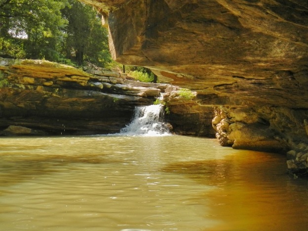
Wedington Sandstone of the Fayetteville Shale at West Fork

DSCN4403

Base of the Wedington–mapped into the upper Fayetteville Shale

DSCN0763

Large septarian concretion–lower Fayetteville Shale

Img0033DSCN5622

Pyritized Holcospermum (seed fern seed-left) and goniatitic ammonoid (right)–lower Fayetteville Shale

DSCN5822

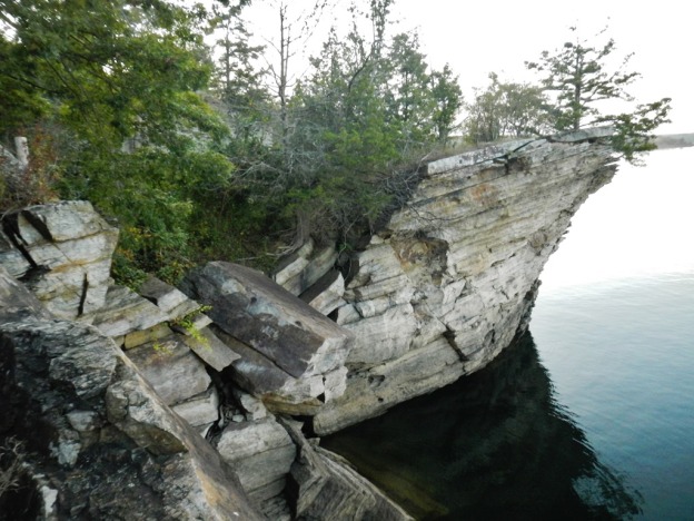
Boone Formation, along the White River in the northwest corner of the Durham quadrangle

This year, we’re moving east to map the Japton and Witter quads. Wish us luck as we begin a new field season.  We’ll try to keep you apprised, so until next time, we’ll see you in the field!

DSCN5534DSCN4657

Richard Hutto and Garry Hatzell

Statemap 2015-16 Update


Hello all!

Well, another year, another map!  The Brownsville quad is now published (see map below), and a link to it will be posted on our website soon.  This year marks the 22nd anniversary of Statemap, aka the National Cooperative Geologic Mapping Program, in Arkansas.  Statemap is partially funded by a USGS grant, and was established to encourage the states to map their surface geology at the 1:24,000 scale.  To date, our mapping teams have completed thirty-three quadrangles in the West Gulf Coastal Plain and, with the recent publication of the Brownsville quad, forty quads in the Ozark Plateaus.

Geologic map Brownsville, AR

The geology of the area around Greers Ferry Lake has never been mapped in great detail until now.  Previous work had been to produce the 1:500,000-scale Geologic Map of Arkansas.  Because we mapped the Brownsville quad at the 1:24,000 scale, we were able to make some observations new to science.  A fault was discovered that had never been mapped previously.  We named it the Shiloh Fault for the old town, now inundated by the lake, that lies along its trace.  Meanders of the Little Red River channel approached this fault but didn’t cross it, probably due to encountering more resistant rock on the north side of the fault.  The Witts Springs Formation had not been mapped south of the Choctaw Creek Fault before, but we were able to draw in its upper contact with the Bloyd Formation along the Devil’s Fork and several other drainages.

Overturned cross beds in massive sandstone of the undifferentiated Bloyd Formation

As on other quads around Greers Ferry Lake, we continued to find terrace deposits left behind as the Little Red River carved the valley down to its present elevation.  Some of these are stranded as much as 260 feet above the current channel bottom (now located on the bottom of the lake).

DSCN0999

For many years now, our mapping program has focused on completing the Mountain View 1:100,000-scale quad.  This area encompasses thirty-two 1:24,000-scale quads and stretches from Richland Creek to Sylamore Creek on the north side and from the Illinois Bayou to Greers Ferry Lake on the south side.  Now that this area is finished, our Statemap Advisory Committee has decided we should jump over to northwest Arkansas to complete work on the Fly Gap Mountain quad, just west of the Mountain View quad (see map below).

STATEMAP index for blog

So for next year, the Statemap team is going to start work on the Durham quad in the northwest corner of the Fly Gap Mountain quad near Fayetteville.  We’ll have to spend a few weeks getting our feet on the ground, so to speak, because we won’t have the benefit of already mapped quads adjacent.  Fortunately, we will be very close to the type-sections for most of the formations we’ll be mapping, so hopefully, we can study the classic outcrops and trace them into our new field area without too much difficulty.

DSCN0704

A type-section is an area, or even just an outcrop, where a particular formation was first described.  They are named after a local geographic feature.  Formations first described in northwest Arkansas include: the Fayetteville Shale, the Pitkin Limestone, and the Hale Formation which has the Cane Hill and Prairie Grove as members.  Members are smaller, discernable units within a formation.  The type-section for the Bloyd Formation, including the Brentwood, Woolsey, Dye, and Kessler Members, and the Trace Creek, which is the basal member of the Atoka Formation (named for its type locality in Oklahoma), is on Bloyd Mountain near West Fork.

I would like to take this opportunity to thank my field partners that accompanied me this past year.

DSCN2086

I started the year with Ty Johnson, who has since moved into a permanent staff position at the Survey, so congratulations to him!  He was with me for just a year, but we covered a lot of ground together.  He’s now mapping the geology of the Lake Ft. Smith area with an emphasis on landslide mitigation.

DSCN2258

The writer and also principle investigator of the Statemap grant, Angela Chandler, went out a few weeks in the late fall before we could fill the vacancy Ty left behind.  No matter how much I learn, she always manages to teach me something new.

DSCN2641

We hired Garry Hatzell, a recent U of A grad, who started fieldwork in January.  He brings an enthusiastic knowledge of paleontology to the mix, and I look forward to his continued insight into the biostratigraphy of our field areas.

Without the help of these fine folks, we couldn’t have gathered the data or produced the map.  Also, I would have been stuck in the office—a torture for the unrepentant field geologist.

Wish us luck on the Durham quad!  And if you’re in northwest Arkansas during the next twelve months and happen to drive by a Jeep Cherokee with the AGS seal on it, be sure to stop and introduce yourself.

 DSCN3153

Until then, I’ll see you on the outcrop!

  DSCN2275       

Richard Hutto