
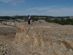
 The intersection of I-630 and I-430 is undergoing a major overhaul in west Little Rock, Arkansas. Excavation, during 2011 to the southeastern corner of this intersection, exposed a spine of Pennsylvanian Jackfork Formation sandstone and surrounding shale. Due to hardness of the sandstone at this location, it was decided to leave this rock outcrop and the name Big Rock Interchange was adopted. Anyone traveling through this interchange will be able to see this outcrop as it is very prominent.
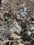
The Jackfork was deposited about 318 million years ago in a deep water marine environment by turbidites, landslides, and other mass wasting events some of which happened very rapidly while others very slowly. In total, the formation is about 6500 feet thick, was deposited in about 2.5 million years and is part of the Ouachita Mountain Physiographic Province. Deep water, in this instance, means 5 to 8 thousand feet deep. Fossils of any kind are hard to find in this type of environment. The sandstones at this site are harder than normal and have been upturned to the point they are almost vertical. The process of hydrothermal silica-rich waters passing through the rock in the distant past cemented the sand grains together well enough to now call the rock a quartzite. The difference between sandstone and quartzite is evident when broken. Quartzite breaks across the sand grains while sandstone breaks around the sands grains. A hand lens, magnifying glass or microscope is really needed to see this phenomenon. One may ask why the spine of sandstone is nearly vertical. This is due to tectonic plates colliding and deforming the rocks. The collision between tectonic plates forming the super continent Pangaea caused folding and faulting as the rock in an ancient sea were pushed northward onto the North American tectonic plate. Fault gouge collected in 2011 suggest that a minor ancient fault occurs somewhere on this outcrop which is now hidden.
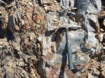
 At least two generations of quartz veining is evident at this site. Some veins are coarse-grained while others are finer-grained and they cut across each other. This is called cross cutting relationships and demonstrates that the quartz veining occurred at two different times. Cookeite, an accessory mineral, was deposited along with the vein quartz. Cookeite, lithium-rich mica, is known to occur in the Little Rock/North Little Rock area. We found occurrences of Cookeite while investigating this exposure in 2011 in some of the quartz veins. When fresh, the Cookeite has a blue-green color and is less than 1/16inch in diameter.
Additional places to view the Jackfork Formation in the local area are Pinnacle Mountain State Park, along Hwy 10 south of Lake Maumelle (Maumelle Chaotic Zone), Big Rock Quarry and the west side of the McCain Mall parking lot. These locations all have wonderful outcrops which display different depositional styles and settings and are very easy to access. One not so accessible outcrop of the Jackfork that many people see every day occurs along I-430 south of the Arkansas River. Along this section of roadway, Jackfork sandstone and shale beds are nearly vertical and make up the south limb of the Big Rock syncline.
-
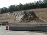
- As construction nears its completion, Big Rock is very prominent, July, 2013
-
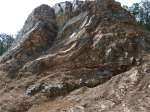
- Up close, the Jackfork Formation at this site shows deformation caused by the building of the Ouachita Mountains
-
- Milky quartz veins were exposed in 2011 during the early phases of construction. Hammer for scale
-
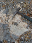
- Notice the lower half of this quartz vein is much finer-grained than the upper part suggesting two periods of quartz emplacement
-
- AGS geologist examines the Jackfork Formation sandstone spine in 2011
-
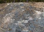
- Sandstone and shale exposed in 2011 exposed during the construction at the I-630/ I-430 interchange
-
- The blue-gray sandstone is very hard and slow to weather verses the shale which surrounds it
