Hello campers!
Well, much drier this week, but of course the heat is back!

Ferns on Nubbin Ridge

Paw paws on Middle Fork

Mushrooms on Lost Creek
We’re still working on the Shirley quad this week. Started out Monday by dropping down a steep side drainage off Nubbin Ridge nearly to the Middle Fork, then right back up another one. Got good points at the base of the Witts Springs and Cane Hill. The Imo is at the bottom of the valley but the very large boulders eroding at the top cover most of it. Relief was around 400 feet.

Typical Witts Springs on Lost Creek

near Cane Hill top (1)

Cane Hill (2)

Cane Hill (3)

Cane Hill (4)

Cane Hill (5)

Cane Hill (6)

Cane Hill (7)

near Cane Hill bottom (8)

near top of Imo
Tuesday and Wednesday we were back in the headwaters of Lost Creek. There are many branches to this creek, and there seems to be a fairly large structure crossing them approximately east/west. Could be a fault, or maybe just a fold of some kind—will take much more data collection to be sure. We did observe a repeating sequence from higher elevations to lower—now we just have to figure out which formation they are in! In the Ozarks, the Pennsylvanian-aged rocks are a series of sandstone and shale units deposited in a shallow marine environment. That means they are all very similar to each other and the differences are subtle and vary from place to place. To differentiate one formation from another, we depend a lot on context, which means we must take meticulous notes on each outcrop in the hopes we can see a pattern in the stratigraphy that matches something known. We’re starting in the northwest corner of Shirley because we’ve already mapped the surrounding quads in that area, so have a pretty good idea of the geology there. Things are getting more complicated as we reach the structure because the strata are displaced somewhat from one side to the other. We will continue to add points next week in order to discover what the rocks are doing there.

ripple beds
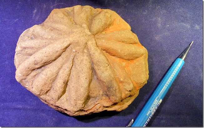
Since I’ve mentioned some of the formations in the area and how difficult they are to differentiate, let me discuss one that has stayed fairly consistent across the Boston Mountains Plateau. The Cane Hill is a Member of the Hale Formation, and its type section is in northwest Arkansas. It is typically very thin- to thin-bedded, ripple-bedded, very fine-grained sandstone with interbedded shale and thicker shale units. There are abundant trace fossils in the Cane Hill including asterosoma which is a somewhat star-shaped feeding burrow.
Trace Fossils:

trace fossil

trace fossil

trace fossil

trace fossil

trace fossil
Asterosoma:

asterosoma

asterosoma
 Bluffs of this sandstone often affected by a particular weathering phenomenon where the cement holding the sand together actually solutions out which lets the individual grains fall away eventually forming a concave structure. I have included a good set of photos of the Cane Hill and a few of its characteristic structures. It is getting to be over 300 feet thick as we continue to map toward the southeast.
See you next week!
Snake count: 2
Conostichus count: 1
Tick attacks: moderate to heavy


