While in the field, we study as many rock outcrops as we can to learn about the geology of the area. Features present in the rocks can help us figure out what tectonic forces affected them. Faults are one type of feature that provides evidence for past tectonic forces.
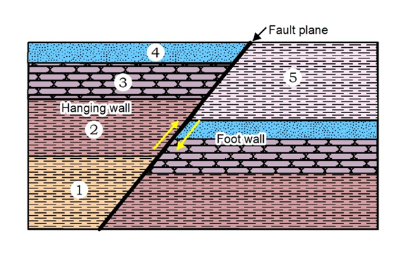
A fault is a natural break in the rock where one block has moved relative to the other. Imagine that each block in the diagrams below are rocks with each color and pattern representing a different rock formation such as limestone or sandstone. Visualize that the fault plane is a natural crack or fracture in the rock. You are standing with your feet touching the bottom the footwall, hence the name. Look from one side to the other. Notice that each rock formation is offset or displaced across the fault plane.

It can be difficult for geologists to locate faults in the field since outcrops of rock don’t always look as pretty as these diagrams! However, we have been lucky enough to come across features that form on fault surfaces called slickensides.
Slickensides are smooth rock faces with linear grooves (also known as striations, lineations, or slickenlines) that form as a result of friction during fault movement. These are important features because they can tell geologists the general direction of movement along a fault.
Let’s take a look at the example below. On this rock face, the polished slickenside surface shows slickenlines indicating that this rock body moved in either an upward or downward direction relative to the one it was sliding against (which has since weathered and eroded away) during faulting.

While lineations and grooves can be helpful, they don’t always tell geologists the exact direction of movement. In the picture above, we can narrow down the movement of the existing rock surface to two directions: upward or downward. However, what would be even more helpful is some sort of indicator to tell us the exact movement of both sides of the fault (yes, even if one side of the fault is missing!). This is important because as we saw earlier, different types of faults tell us about the directions of tectonic forces that were acting on the rocks in the past.
So, how can we know the exact direction of movement along a fault?

Along with formation of groove lineations, mineral fiber lineations can grow in small cracks in the rock in the direction of movement during slickenside formation. This results in a stair step pattern on the slickenside surface, where the “down steps” point in the direction the missing fault block moved.

When a geologist runs their hand on a slickensided surface with fiber lineations, one direction will feel rough, and the other smooth. The smooth direction is the direction that the missing rock surface moved, meaning the existing surface moved in the opposite direction. We can now tell the exact direction the fault moved!
Let’s take a look at a chert rock surface.

The polished slickenside surface above was produced by movement along a fault. The surface is parallel to the fault plane. At this surface we take a compass direction (trend of the fault trace) along the outcrop to measure its orientation. For the outcrop above, the fault trend or strike is 76 degrees to the west. The fault surface is dipping 63 degrees to the south. To determine the direction that the fault block moved, we run our fingers over the slickenside surface to feel for those stair step patterns. The fault plane above is smoothest in a southerly direction, or down the dip of the surface. Therefore, the missing fault block moved downward to the south in relation to the outcrop, making this fault type a normal fault!

We are glad to see this site activated again.
I’d like to see detailed information about the geology of NWA. More than a continental shelf sea… discuss lithification, modification, uplift of the plateau, erosion… Devonian unconformity and how we know it exists.
People see, drive by, bike, hike and more these rocks everyday but don’t understand the geologic history of the area.
Sorry to ask for so much, I meant to say Good Job! But if you are looking for ideas, inquiring minds may wish to know specific local geologic details. (Could be a series for the various regions of the state?)
thanks in advance,
Mr. Phillip Sand Hansel II
Hello Mr. Hansel,
Thank you for your suggestions, we will take them into consideration! If you are interested in diving into some of the geology of NWA, we have a few publications on our website that may be of interest:
https://www.geology.arkansas.gov/publication/guide_books/GB-2018-1-guidebook.html
https://www.geology.arkansas.gov/publication/state_park_series/SPS-04-state-park-series.html
https://www.geology.arkansas.gov/publication/information-circulars/IC-41-information-circular.html
We hope these are insightful!
Thank you very much for the guidebook links. We spent a wonderful day on Beaver Lake where we identified numerous Paleokarst sand deposits. We haven’t taken the whole tour, but plan on doing so soon.
Mr. Phillip Sand Hansel II
BS Geology U of A 1978.
Looks really good and easy to read and understand also it’s not too technical.